1. Home » Navigation » Paddle Ways - Lets Go Paddling
Paddle Ways - Lets Go Paddling

Paddle Ways - Lets Go Paddling

By OnWater, LLC

  • App Category: Navigation
  • Release Date: 2023-06-20
  • Current Version: 2.3.4
  • Adult Rating: 4+
  • File Size: 92.07 MB
  • Developer: OnWater, LLC
  • Compatibility: Android, iOS 13.4
App Ratings: 3.88889
3.88889
Based on 81 Reviews
Advertisement

Paddle Ways - Lets Go Paddling App Description

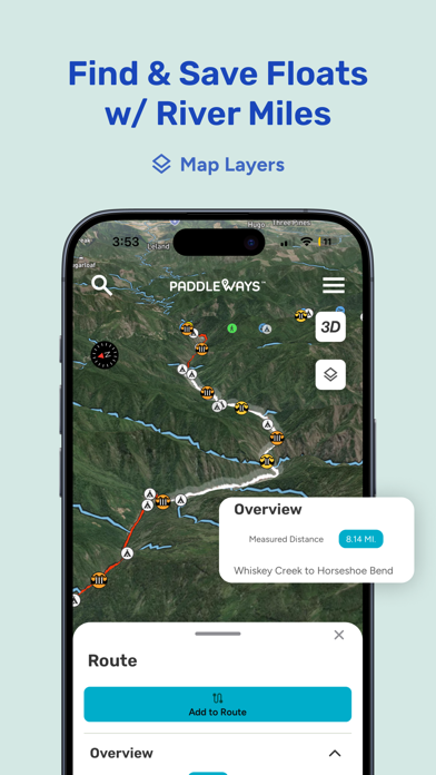
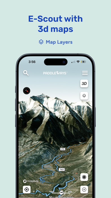
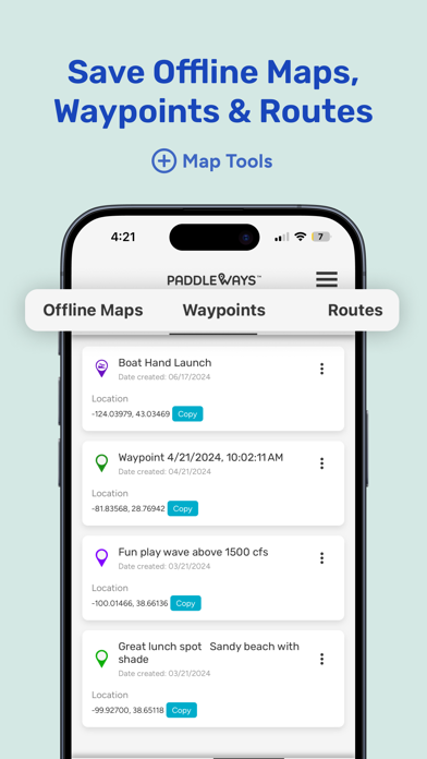
The #1 resource for the Paddling & Rafting community. Get river maps, conditions, rapids intel, and more while sharing important river and lake information with the PaddleWays community. PaddleWays serves as your indispensable digital guidebook and GPS navigation tool for your paddling adventures. Whether you're into kayaking, rafting, canoeing, or stand-up paddling, PaddleWays has got you covered. Developed in collaboration with American White Water, this app provides vital information to ensure safe and informed decisions before your water float trips. Explore Exciting Paddling Destinations Discover a variety of river sections, as well as rivers and lakes, both nearby and farther afield, with our interactive maps. Delve into guidebook descriptions, assess your skill level with provided difficulty ratings, and access related resources for comprehensive insights. Effortless Trip Planning Plan your perfect outing with confidence using PaddleWays. Calculate river miles, access thousands of points of interest, such as access points, boat ramps, campsites, and more. Save your favorite river sections, check real-time weather conditions, and monitor river flow rates (CFS) by location to identify the ideal time for your water float trips. Seamless Navigation Navigate with ease through detailed interactive 2D and 3D maps, accessible both online and offline. Choose from Satellite, Outdoor, and Street map modes, measure distances in river miles, and set location-based alerts for upcoming take-outs, campsites, or rapids. Connect with the Paddling Community Stay informed through user comments on recent conditions and reference notes, photos, and saved locations from your previous trips. PaddleWays is more than just an app; it's an interactive atlas and community forum created for paddlers, by paddlers. Meet PaddleWays PaddleWays is powered by NRS, committed to making human-powered recreation more accessible, safe, sustainable, and enjoyable. Utilizing technology developed by onWater, PaddleWays donates 1% of sales to promote responsible use and resource conservation. PaddleWays Plus Upgrade your experience with a PaddleWays Plus subscription, offering access to premium features, including offline maps, river guidebooks, real-time flow data, and public & private land data. Discover the ultimate tool for your whitewater, kayaking, and rafting adventures. Download PaddleWays today and embark on waterborne journeys like never before. Terms of use: https://paddleways.com/terms-and-conditions

Advertisement

Paddle Ways - Lets Go Paddling App Screenshots

Paddle Ways - Lets Go Paddling App Reviews

  • A great app but I wish they would be honest

    3
    By kopdsaer
    They keep throwing free at you in all the adds and not until you download do you find out they only tease with a little free info and you need to pay to get anything substantial. That said it’s worth the cost I just don’t like dealing with people that work that way.
  • Stoked to see where this goes!

    5
    By agtm1
    I’ve been looking for an app that makes getting on the water easier. I’m stuck in a rut of going to the same place to paddle over and over again.
  • Not worth the money

    1
    By River-guy
    Terrible app, needs a lot of work
  • App is even dangerous

    1
    By JoeNorCal
    No flow info or flow level guidance which is absolutely essential for safety when encouraging river access. Descriptions of rapids I know on the South Fork American are either wrong or incomplete, and a few descriptions provide dangerous advice (Troublemaker (“swim to either side”) and Second Threat (“fun to swim”). A quality company like NRS should not be in the chain of liability for something as incomplete and erroneous as this app. Thankfully, there are plenty of free web sites with far better information on access, safe flows and the runnable lines.
  • Looks and feels good

    2
    By Kevin Boater
    I was really surprised to see just how few rivers are listed in the database. I understand this must be a massive undertaking adding rivers and all the info. My biggest suggestion would be to allow route creation similar to Strava. In that app, which is a similar price point for yearly subscription, it’s very easy to create routes on any river in manual mode. Obviously PaddleWays will(or should) have to make their own user interface for this kind of feature. Given that there’s so many bodies of water it only makes sense to allow info creation from users. I’m in TN and REALLY surprised to see the pigeon on the map but not the Ocoee? I’m interested to see how the developers move forward with this app, but I believe most users are going to struggle to see the value in subscription unless something can happen quickly. I’m also not sure how this service can be better than using AW. Just my thoughts, would love to see where it goes!
  • Not good

    1
    By Ohio Zonian
    I got a ad in a recent NRS purchase, was excited. Once I got into it, it has very little data or rivers for Ohio, and surrounding areas. Rendered it useless for me. It’s basically just a simple mapbox app, nothing special.
  • Hard to tell

    1
    By Gerooge
    It might be a great app, looks like it would be, but I couldn’t really tell. There is supposedly a free 14-day trial to test it out, but every time I tried to access any of the features it threw up an upgrade-to-premium payment screen. I went ahead and payed because I was sure I wanted the features, got an email confirming my subscription and receipt of payment, but it still persists in displaying that annoying upgrade pop-up when I try to access the features. Hence it might be great, but I can’t tell since I still can’t get into anything. I gave it three days to allow time for payment processing, updating status, or whatever might need to happen in that line, but after that when nothing changed I canceled my subscription. No point paying for an app that refuses to be used.
  • Has Potential

    2
    By Pin-seeker
    I think this has potential; but there are significant gaps in the river data. How are rivers added? How can users submit real time beta? From southern Idaho, popular runs are missing. Payette: Cabarton, Canyon, Swirly Canyon. Boise River: No data I think the price point is reasonable if the data is there. At this time, I cannot renew after the trial ends.
  • Password Reset/Forgot Password Function Does Not Work

    1
    By SkipTracingDeadbeat
    Still waiting for reset email
  • Keep it up!

    5
    By takadanobaby
    I love what this app has going so far…maybe they could have saved themselves some of the more mean-spirited reviews by putting BETA in all caps all over. For the info so far it’s a great way to navigate to see different river conditions. Easier than the web browser pages many rely on. I hope this can become a one-stop shop for gauge, CFS, put-in/take-out, parking, restrooms, fees, so we’re not jumping around different apps and sites to plan trips. Meanwhile I appreciate that the named rapids in the Lehigh are marked!

keyboard_arrow_up

Paddle Ways - Lets Go Paddling, android, apk apps, android apk, android app, download apps, Paddle Ways - Lets Go Paddling app, free Navigation android apk app download, Paddle Ways - Lets Go Paddling applications